
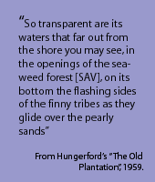
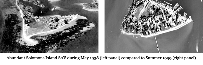
 The Patuxent Estuary like many coastal estuaries has endured great changes as a result of human population growth and development within its watershed over the last century. SAV populations once abundant along the shorelines of the Patuxent are now virtually gone. Historical documents such as "The Old Plantation" (Hungerford, 1859) describe the Patuxent during the mid-1830s as one of the clearest rivers flowing into the Chesapeake. Even in 1938, aerial photographs show the area around Solomons Island supporting healthy SAV populations. More recently (1999), photographs show a complete loss of SAV from this area. An analysis of historical photographs and water quality data coupled with recent epiphyte studies has shed light on the processes that led to SAV decline in the Patuxent.
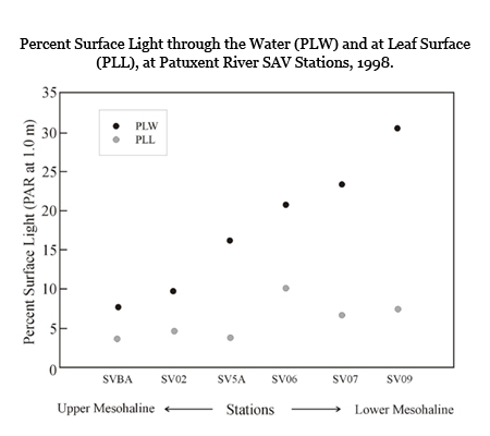 These results suggest that the processes that led to the loss of SAV varied in strength along the axis of the Patuxent estuary. For example, in the upper mesohaline region (near Chalk Point), water clarity was consistently less than established mesohaline SAV habitat requirements suggesting that poor water clarity was sufficient for SAV decline. In the lower mesohaline region near Solomons, water clarity was consistently above SAV requirements, suggesting that other factors may have been responsible. However, high epiphyte fouling rates could have significantly reduced light available to the leaf to levels below that needed for survival.
Experimental results above show that epiphyte fouling at Solomons had the capacity to reduce available light to SAV blades from 30% of surface light at the depth of the SAV (PLW) to only 7% of surface light at the leaf surface (PLL) within a week. As a result, increased water clarity in the lower estuary stimulated excessive epiphyte growth which reduced light to the SAV blade to levels similar to that found in the upper mesohaline region.